US censors satellite images of Iran war, raising transparency concerns
The US pressures Planet Labs to withhold Middle East imagery amid conflict with Iran, limiting independent verification and sparking debates on information control.
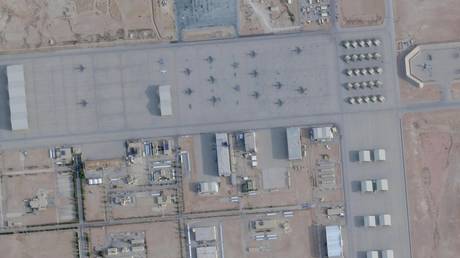
In a move that underscores the militarization of space and information, the US government has pressured satellite imaging company Planet Labs to halt the publication of Middle East photos, specifically related to the ongoing conflict with Iran. The San Francisco-based firm, which holds contracts with US government agencies, announced an indefinite withhold of imagery captured from March 9 onward, citing a White House request. This decision represents an escalation in efforts to control the flow of visual data that previously allowed journalists and open-source intelligence analysts to independently verify damages on both sides, including key sites such as Prince Sultan Air Base in Saudi Arabia and Mehrabad International Airport in Tehran.
The context of this censorship is framed by a conflict that has seen prior restrictions, such as delays in image releases extended from 96 hours to 14 days, purportedly to limit military use. However, the new indefinite withholding policy raises serious concerns about transparency and access to information during wartime. While Planet Labs has indicated it may release select images in cases deemed to serve the public interest, the lack of clarity on criteria and the potential extension of this measure to other companies like Vantor or BlackSky Technology suggests broader governmental control over the conflict's narrative.
Analytically, this episode highlights the tension between national security and press freedom in the digital age. By blocking access to commercial satellite data, the US not only limits independent verification capabilities but also centralizes information within state hands, potentially affecting accountability and public understanding of war events. This occurs at a time when satellite imagery has become a crucial tool for investigative journalism and international conflict monitoring.
Long-term implications are significant: if other firms follow suit, a dangerous precedent could be set for censoring spatial data in future conflicts, eroding trust in information sources and increasing opacity in global security matters. Furthermore, this underscores how governments are adapting their information control strategies in a world where satellite technology democratizes access to intelligence, yet also makes it vulnerable to political manipulation.